Drawings in the Peruvian Nazca Desert
Looks like an unidentified object flying down the river in Buenos Airos— click on the picture to view.
Well of course it's not UFO, but what is it, look for yourself.And what is this a figure that looks like a flower, or maybe this is a landing site for a spaceship?
Indian head in the mountains of the USA— click on the picture to view.
Atacama, Giant Inca drawing— click on the picture to view.
China.
Coordinates 40.458779,93.313129 Airplane siteChinese pattern
40.458181,93.388681
Another chinese pattern
40.451323,93.743248
40.480381,93.493652
And when was this one applied?
Is there anything to hide behind these? black rectangles?
62.174478,-141.119385
In addition to black squares, there are also
66.2557995,179.188385
The famous Area 51, where UFOs and aliens are allegedly hidden
37°14"13.39"n, 115°48"52.43"w
There are also such closed colorful zones in cities.
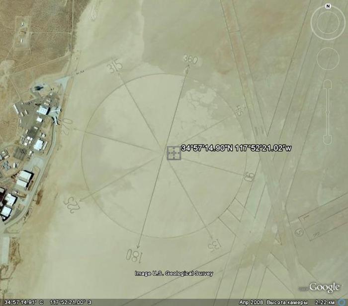
52°14"55.40"n, 4°26"22.74"eWho needs a compass at an altitude of 2 kilometers?
34°57"14.90"N 117°52"21.02"wArrows on the underwater bottom that are only visible from above.
32°40"36.82"n,117° 9"27.33"e
The rocket flew and did not reach
38°13"34.93"n, 112°17"55.61"w
Ground drawing of some animal
31°39"36.40"n, 106°35"5.06"w
UFO landed in a grove
45°42"12.68"n, 21°18"7.59"eA sight measuring hundreds of meters
37°33"46.95"n, 116°51"1.62"wColorful lakes on the outskirts of Baghdad
33°23"41.63"n, 44°29"33.08"e
33°51"3.06"s, 151°14"17.77"e
Rock paintings in Oregon, visible from a height of 1.5 km
+42° 33" 48.24", -119° 33" 18.00"
Another triangle
-30.510783, 115.382303Apparently the remains of an ancient civilization under water. Pay attention to the size of the building and the height of the shooting...
31°20"23.90"n, 24°16"43.28"wTürkiye, Noah's Ark
The anomaly near Mount Ararat is a geological formation of an unusual shape. It is located at an altitude of 4725 meters above sea level and has a length of almost 183 meters. To date, there are three main versions that explain its occurrence - it could be a geological formation, a glacier, or... the remains of Noah's Ark.
There are legends among local residents about a huge old ship on the top of a mountain near Mount Ararat. Writer Charles Berlitz in his book “The Lost Ship of Noah” cites the testimony of the Armenian George Hagopian.
Georgiy Hagopyana said that in 1905, as an 8-year-old boy, he was on Mount Ararat with his grandfather. And that they found the ark and visited inside. On the upper deck, Georgy saw a superstructure with many windows. The body of the ark was huge and hard as stone.
The American magazine New Eden in 1939 published an interview with a former pilot of the Russian tsarist army, Lieutenant Roskovitsky, who allegedly discovered an object resembling an ark back in 1916 during a reconnaissance flight. Roskovitsky reported to the tsar, and Nicholas II equipped an expedition of 150 people. It took them two weeks to reach the site. According to Roskovitsky, the ship resembled both a giant barge and a freight car, and inside there were many rooms - small and large. Moreover, the small rooms were covered with metal mesh.
But the first significant evidence of the existence of an unknown object on the top of the mountain is considered to be photographs taken by American pilots in 1949. A few years later, something resembling a ship covered with snow was seen by Turkish soldiers. The object was then photographed two more times: in 1973 by the American spy satellite Keyhole-9 and in 1976 by the reconnaissance satellite Keyhole-11. CIA workers processing satellite images in the 70s found it difficult to interpret the data obtained. Porcher Taylor, who worked for the CIA at the time, says the picture was quite unexpected. But he was unable to clarify what exactly was there, because the materials collected by Keyhole-9 and Keyhole-11 are still classified.
Coordinates: 39.440628,44.234517World Seed Bank on Spitsbergen
78°14"23.12"N, 15°27"30.19"ENeftegorsk is a ghost town, completely destroyed in 1995 after an earthquake of 9-10 magnitude
52°59′45″ n 142°56′41″ e
Another strange structure in the desert
30.029281,30.858294
An anomalous place near the city of Osoyoos in Canada - Lake Khiluk
49° 4"42.70"N 119°33"58.79"W
Ushtogai square
50 49"58.38N, 65 19"34.54E
— is a geometric figure consisting of 101 mounds in the form of mounds. The side length of the square is 287 meters! Approximately 112 m from the northwest corner, three rings, each 19 meters in diameter, are located diagonally.
On the opposite side, at a distance of 112 meters from the south-eastern corner, there is an embankment with a diameter of 18 meters. If the square, rings and mound are a single figure, then the length of the figure is 643 meters!The structure in Antarctica is clearly not of natural origin. Dungeon entrance
-66.603547, 99.719878
Four strange balls in Peru
13°33"39.26"s, 75°16"05.80"wUFO in the Area 51 area?
Larger
Chanquillo, Spanish Chankillo is an ancient monumental complex on the desert coast of Peru in the Casma oasis in the department of Ancash, Peru. Among the ruins are the hilltop Fort Chanquillo, the Thirteen Towers solar observatory, living quarters and public meeting areas. It is assumed that the Thirteen Towers Observatory was built in the 4th century. BC e. The area of the monument is 4 square meters. km. It is assumed that it was a fortified temple.
“Mandala” is the most mysterious geoglyph of the Palpa plateau, located 30 km from the more famous Nazca plateau. In addition to it, there are many geoglyphs on the plateau; it’s a pity that they cannot be clearly seen in Google Maps (and Earth). The geoglyph “Mandala” or Estrella (i.e. “star”), as the locals call it, is definitely the most amazing of them. According to scientists, it was created in the 2nd century AD. Nazca civilization. The composition of two drawings has a size of about two hundred meters and the mystery, as you may have guessed, is how in ancient times people were able to create such a geometrically correct drawing, which is entirely visible only from a bird's eye view. There is an opinion that the geoliths of the Nazca and Palpa plateaus carry information encoded in mathematical form from their creators, be they people or someone else.
Several videos on this topic
An earthquake, a plane crash, a fire, a geoglyph of Russia, drawings in the fields and other interesting places on the planet. The coordinates of all places are given. In some places, you need to change the date to see what's in the video (where Google frequently updates photos).
23° 6"54.45"N 113°19"3.79"E Game center, China
35°38"6.01"N 139°44"40.63"E Tokyo, Reclamation Center
33°26"19.18"N 111°58"51.41"W drawing at the airport, USA
35°41"18.90"N 139°45"19.90"E Tokyo, flower
45°38"27.65"N 122°47"43.01"W drawings in the USA fields
52° 2"33.57"N 4°12"47.26"E Sundial, Netherlands
51° 3"16.04"N 1°58"42.45"W Medals, UK
52°31"15.93"N 13°24"34.08"E TV Tower Berlin
37°47"30.27"N 122°23"23.57"W Bow and arrow, San Francisco
35°46"52.68"N 139°35"59.27"E Note, Japan
54°56"30.29"N 59°11"35.85"E Geoglyph "Elk", Chelyabinsk
32°51"31.47"S 70° 8"31.76"W Highway, Chile
46°45"56.81"N 100°47"34.26"W Accident, USA
36°10"58.55"N 68°46"37.34"E Afghanistan (Afghanistan)
55°57"4.82"N 3°13"35.22"W Spiral, Edinburgh
23°38"44.11"N 57°59"13.14"E House in the shape of a heart with an arrow, Oman
34°55"29.03"N 139°56"32.84"E Rybka, Japan
52° 9"14.17"N 2°14"53.03"W Frog, UK
43°42"53.23"N 112° 1"4.04"E Geoglyph giraffes of Mongolia
43°27"25.38"N 3°32"39.48"E Dinosaur, France
29°10"32.51"N 34°42"6.29"E sand drawing, Egypt
50°41"53.40"N 3°10"8.99"E Car on the roof of a house, France
39°44"57.08"N 105° 0"23.02"W Pepsi Center, USA
42°54"6.25"N 22°59"31.76"E Medal, Bulgaria
35°42"13.37"N 140°50"21.12"E Consequences of the 2011 Japan earthquake
37.790699,-122.322937 Plane crash (only google maps!) plane crash- only google maps
42°19"59.78"N 83° 3"19.94"W drawings, America
43°17"25.51"N 80° 1"42.35"W Field in Canada
51°56"57.39"N 7°35"25.43"E Dinosaurs near the History Museum, Germany
56°40"45.06"N 12°48"42.85"E 3 hearts, Sweden
52°30"36.12"N 13°22"19.99"E Sony center, Germany
26° 6"57.47"N 80°23"48.39"W City on the water, USA
39°51"37.23"N 4°17"5.20"E secret place in Spain
69°10"36.03"N 33°28"27.51"E Overturned ships, Murmansk region
43°34"35.10"N 28° 9"4.00"E Pozhar, Bulgaria
52°32"15.37"N 13°34"28.10"E Labyrinth Germany
21°35"4.41"N 39°10"33.58"E "Cosmos", Saudi Arabia
25°14"3.58"N 55°18"3.48"E balls, Dubai, UAE
33°36"6.59"N 111°42"38.98"W Fountain, USA
51°34"38.38"N 0°41"49.54"W Airplane takes off, UK
53°27"5.16"N 113°44"4.84"W fig. in Canada, Formula 1
12°21"55.53"N 76°35"41.31"E INFOSYS-inscription from residential buildings, India
53°48"49.58"N 3° 3"16.87"W Skull, UK (change date)
15°49"32.22"S 47°56"7.71"W Star, Brazil
51°58"14.47"N 4°12"1.03"E MiG 23, Netherlands
52°30"28.86"N 13°23"9.32"E Globe, Berlin
35°41"30.80"N 139°41"49.08"E Cocoon Tower Tokyo
55°24"0.17"N 10°23"7.93"E drawings, Denmark
40°35"44.02"N 141°24"27.53"E Fish, Japan
6°37"43.75"S 31° 8"10.10"E Hippopotamus Lake, Tanzania
47°16"52.49"N 0°50"51.44"W drawings in the fields of France
70°14"24.91"S 69° 6"25.56"E Strange object in the snow of Antarctica
33°49"46.31"N 130°28"4.68"E Sunken plane, Japan
59°57"16.63"N 30°20"15.96"E Cruiser "Aurora" St. Petersburg
25°11"46.30"N 55°16"36.87"E Burj Khalifa, Dubai, UAE, 828 meters. Burj Khalifa, Burj Dubai
3° 0"8.59"S 33° 5"24.30"E Tanzania market
66°17"50.90"S 100°47"7.55"E Ice began to melt in Antarctica
67°25"48.55"S 60°52"35.18"E "Hand" in Antarctica)
40°41"21.15"N 74° 2"40.34"W Statue of Liberty, USA
41°40"2.82"N 86°29"32.18"W Studebaker
41°45"39.13"N 86°16"9.39"W St. Patrick's Park, USA
44°58"1.39"N 124° 1"7.43"W bear
47°35"43.11"N 122°19"51.84"W Football match
48° 1"39.15"N 122° 9"50.93"W Labyrinth, Washington
21°50"21.11"S 46°34"3.04"W in Brazil
28° 0"21.90"N 86°51"33.79"E Tent camp near Mount Everest
29°50"36.13"N 47°50"49.45"E Fire
35°17"2.60"N 33°22"21.11"E Cyprus, flag
44°45"39.41"N 20°28"19.73"E name of the former president of Yugoslavia
44°34"54.07"N 38° 6"13.78"E Gelendzhik
48°48"18.82"N 2° 7"8.93"E Skeleton, Versailles
50° 3"8.21"N 8°36"51.04"E aircraft
50°56"17.25"N 5°58"40.80"E NATO headquarters Netherlands
52°19"36.22"N 4°55"11.33"E Newspaper parking lot, Netherlands
52°25"50.72"N 4°23"24.12"E Boat and plane
51°17"6.09"N 30°12"44.47"E Chernobyl-ship graveyard
69° 3"38.05"N 33°12"18.76"E Nuclear submarine "Kursk"


The navigation system from Yandex is used by a large number of people living in the CIS. Convenience and ease of use are perhaps the most important characteristics of Yandex Navigator. Despite these characteristics, some aspects of the application raise questions even among experienced users. One of the frequently asked questions is “How to enter coordinates into Yandex Navigator?” In today’s material, our resource will answer exactly this, paying attention to all the subtleties.
Coordinate format
In order to understand how to enter coordinates into Yandex Navigator, it is important to have an idea of their format. As is known from the school geography course, the coordinates of a certain place are indicated using the degree measure of its latitude and longitude, which in a certain way penetrate the entire globe. In navigation from Yandex, the format for displaying and entering coordinate data fully complies with generally accepted standards. As a basic example, you can take a coordinate such as “21 o 43’54.67’’N” for latitude and “11 o 23’34.77’’E” for longitude, where:
- 21 o and 11 o - degrees of latitude and longitude;
- 43’ and 23’ - minutes of latitude and longitude;
- 54.67” and 34.77” - seconds of latitude and longitude;
- N (North - North) and E (East - East) - direction indicators.
Note that navigation from Yandex only supports degree coordinate format. More precisely, by entering the exact indicators of a specific longitude and latitude into the appropriate fields, it is quite possible to find a given place. The method looks like “45.342324” for longitude and “32.34234243” for latitude.
Important! You can enter coordinates in Yandex Navigator using any of the methods described above, except when the input field requires a specific one of these data formats.

Entry procedure
When wondering how to set coordinates in Yandex Navigator, many people not only do not understand how simple it is, but do not even suspect that in this application you can find out the coordinate data of a specific place and save it for future use. The latter, by the way, is very useful if you want to use navigation offline (that is, without an Internet connection).
So, returning to the procedure for entering coordinates, let's look at its typical procedure:
- Firstly, it is important to find out the coordinates of a specific location. The most preferable presentation format would be in the form of degrees with a decimal “tail” (32.3231321), since this type of data is recognized in absolutely all versions of Yandex Navigator, while the other previously discussed format began to be used for information search relatively recently. Note that to search for a place, it is important to know both its coordinates, that is, longitude and latitude.
- Secondly, the existing coordinate data must be entered into the appropriate field of the application. To do this, just go to the search menu (click the magnifying glass icon) and enter the coordinates, separated by commas, in the order: latitude, longitude (22.323132, 21.543555).
- And thirdly, all that remains is to click on the search button, after which the place with the given coordinates will be found. You can plot a route to the found position on the map, view the presence of traffic jams, determine the distance, and perform other navigation functions from Yandex relative to it.

It is worth noting that in the latest versions of the application the following features have appeared:
- enter coordinates in the format “degrees, minuses, seconds, location”;
- communicate coordinate data to the navigator using your voice;
- listen to given coordinates after they are found (information is provided in the format “degrees, minuses, seconds, location”);
- set a route solely based on coordinate data; to do this, just select the appropriate function and enter the coordinates of the place where you want to lay the path.
Answers to frequently asked questions
Now that everything is clear about how to enter GPS coordinates for a specific location in Yandex Navigator, it would be useful to consider other frequently asked questions about using this application. Having studied the relevant forums, our resource has identified the three most asked questions

and provided the answers to them below:
- Is it possible to work Yandex Navigator without access to the Internet?- Yes, however, in this case the application will not perform all functions. More precisely, the navigator will not be able to show existing traffic jams or provide information about places of stay. At the same time, to work with the application offline, you need to download maps of the area of your movement, then turn on the GPS module on your device and use navigation.
- How to download or update Yandex Navigator?- To do this, just go to the application on your device called GooglePlay or AppStore and find navigation from Yandex in the search, after which you can carry out the necessary operations on an intuitive level.
- What should I do if Yandex Navigator does not work correctly (does not indicate the route, displays maps poorly, etc.)?- In order to configure the application, you must perform the following steps: restart the application, restart the device, check the Internet connection and GPS, reinstall the application. Naturally, it is necessary to stop carrying out these manipulations when the desired result is achieved.
With this, perhaps, today’s article has come to its logical end. We hope that in the material presented above you have found answers to your questions. Good luck on the roads!
Video review of the program:
Google Maps is the most popular mapping service that was developed in 2005. But we will not delve into the history of its creation, advantages, etc. We'll talk about what secret places there are in Google Maps. Interested? Then read this article.
Google Maps - what is it?
As you may have already understood, in this article we will look at secret places in Google Maps. But first, for those who are not in the know, it’s worth briefly explaining what Google Maps is. Essentially, this is a map that covers the entire Earth (for those for whom this is not enough, you can additionally look at the map of Mars and the Moon). Thanks to Google's high-tech satellites, this map very accurately and clearly displays even the most remote corners of the planet.
But, perhaps, let's return to our sheep. Want to know where the secret places are in Google Maps? Read this article!
As you know, Google employs some very funny people. Developers are constantly adding some features, Easter eggs, and secrets to their software. For example, did you know that if you type the phrase “Google gravity” into the Google search bar and open the first link, you can observe how it affects the links, icons and pages of your browser.
And this is just one of thousands of examples. Google developers constantly insert some funny features into their creations. The mapping service from this company was no exception. The developers have also added so-called secret places to Google Maps. secret and interesting locations that are marked on the map. In this article we will talk about how to find them.
Secret places in Google Maps: coordinates and their descriptions
Well, let's not drag our feet and let's jump right in. Below we look at the strangest places on Google Maps.
By entering coordinates 66.266667, 179.250000, you can observe an unknown area of Siberia, located near Alaska. What's there? This question excites the minds of many Russian residents.
By entering the coordinates 37.7908, 122.3229 into Google Maps, you can observe a real plane crash. The map shows a plane broken in two. It is not known for certain whether this is a real disaster or an ordinary production.
At coordinates 36.949346,122.065383 you can see a skeleton of quite impressive size. It’s creepy to even imagine what animal these bones belong to.
If you're a conspiracy buff, this next location is sure to pique your interest. By entering the coordinates 32.664162, 111.487119, you can see the secret BBC base, which is located in the United States of America. It is not known for certain what they are doing at this base, but if you wish, you can find a lot of the most fantastic theories on this matter.
By typing 54 28"6.32", 64 47"48.20" into the coordinate line, you can see a rather interesting picture. At this location, the inscription “Lenin 100 years”, which consists of trees, is clearly visible.

Sci-Fi lovers should type 19 56"56.76"S, 69 38"2.08"W into Google Maps. At these coordinates there is a drawing that strongly resembles an alien. Is this really the work of an extraterrestrial civilization?
Well, since this is the case, let’s not stray too far from the topic of aliens. At coordinates 45.70333,21.301831 you can see a real UFO hiding among the trees.
By entering the coordinates 45.408166, 123.008118, you can see the plane “parked” in the middle of the trees.
Remember how, as a child, playing on the beach with a shovel and a bucket, our parents told us something like: “Wow, what a deep hole, just a little more and you’ll dig all the way to China!” We took it as a joke, but apparently it was a very real warning. Don't believe me? Then enter the coordinates 38.85878007241521,111.6031789407134 into Google Maps and see a giant hole right in the middle of China!

At coordinates 44 14"39.45", 7 46"10.32" you can see a huge pink hare. It’s scary to imagine the “little” girl who played with him.
We've all probably heard and read about the notorious Area 52. By typing the coordinates 37.401437, 116.86773 into Google Maps, you can also look at this top-secret base.
Did Google Maps help you solve a murder?

There is also one interesting story that deserves special attention. At coordinates 52.376552, 5.198308 you can see the reservoir of the city of Almer. The pier, the trees, the beautiful landscape - everything would be fine if not for one detail. In the photo you can see a man dragging a corpse to the lake. The Google satellite captured a small pier, several figures and a suspicious trail that could be mistaken for blood. But everything is not as it seems at first glance. In fact, there was no murder.
As one reputable publishing house later found out, the card depicted the retriever Rama, who went for a walk with his owner Jacqueline Quenen. The dog simply jumped into the water and then ran to its owner, who was standing on a wooden pier. The frame left behind a wet trail, which Internet users mistook for blood.
The owner of the dog, who saw the photo on the Internet, helped shed light on this “murder.”
Conclusion
Hello, dear friends of the portal site!
Tool - determination of geographical coordinates on a Google Maps map of a city, street, house, in real time. How to determine coordinates by address - latitude and longitude on the map, convenient search by coordinates in Google (Google Maps). A world map with coordinates (longitude and latitude) will allow you to find any address using already known parameters, calculate the distance between two cities/points online
Fill out the Google Maps search form - enter the city, street, house number. Enter the name of any geographical feature separated by a space. Or move the marker to the desired location yourself and search (click “Find”) using the coordinates of the object on the Google map. A similar search has already been used when searching in . Use the change in the scale of the diagram (the desired scale will appear in the third field from the top) to take a closer look at the location of the house on the street.
As you may have noticed, when you move a label on the diagram, the geographical parameters change. We get a kind of map with latitudes and longitudes. Previously, we have already worked on determining coordinates on the Yandex map
Using the reverse method, everyone will be able to search by coordinates in Google using known parameters. Instead of the geographical name of the object, we fill out the search form with known coordinates. The service will determine and show on the map the exact geographical location of the street or area.
Interesting places in Google Maps - online secrets from satellite
Knowing the address of any city in the world, the latitude and longitude of Washington and Santiago, Beijing and Moscow can be easily determined. accessible to both city guests and local residents. We are sure that you have already been able to master this tool on the page; by default, the map shows the center of the capital of Russia - the city of Moscow. Find your latitude and longitude on the map at the address.
We propose to find out the secrets of the Google Maps service online. The satellite will not fly past interesting historical places, each of which is popular in a certain part of the globe.
Below you can see for yourself that these interesting places on earth deserve special attention. And the Google Maps Sputnik service is happy to offer you to find and see the most famous geographical secrets of the world. We believe that residents of the Samara region will also be interested. They already know what it looks like.
You do not need to determine their geographic coordinates and search for the necessary Google maps service. Just copy any parameters from the list below - latitude and longitude (CTRL+C).
For example, we will watch from a satellite (switch to the “Satellite” scheme type) the largest stadium in the world and Brazil - Maracana (Rio de Janeiro, Maracana). Copy the latitude and longitude from the list below:
22.91219,-43.23021
Paste it into the search form of the Google Maps service (CTRL+V). All that remains is to start the search for the object itself. A mark with the exact location of the coordinates will appear on the diagram. We remind you that you must activate the “Satellite” scheme type. Everyone will choose a scale +/- that is convenient for themselves in order to better see the stadium in Brazil
Thank you to Google Maps for the data you provided.
Cartographic data of cities in Russia, Ukraine and the world
The Google Maps service allows you to find a place on the map not only by keywords, but also directly by GPS coordinates. This is convenient if your navigator is not connected to your computer, but you need to show a fragment of the map on a large screen.